Plotting a bearing onto your map
- Bearings, Azimuths, Headings, and Course
- Some reasons to plot bearings onto your map
- Location by Resectioning or "Where am I?
- Location by Intersection or "Where is the ______ that I can see in the distance?
- Plotting straight line course segments for route finding
- The example problem used in this tutorial
- Understand your north references
- Understanding forward and back bearings
- Techniques for plotting a bearing:
- Plotting a bearing using a protractor
- Plotting a bearing using a baseplate compass
- Plotting a bearing using a baseplate compass adjusted for declination
- Plotting a bearing using a straight edged lensatic compass
- Plotting a bearing using a round lensatic compass
- Plotting a second and third bearing to confirm your position
- Using bearings to locate a distant target
- Some exercises to download and try
- Plotting Bearings Exericse Map This file is just the map. The description of the problem and the answers are in the lecture slides. (see link below) Here is the map with the answers plotted Plotting Bearings Answers
- Locating the Smoke Exercise This is a complete exercise for locating an unknown location using intersecting bearings. This is the answer map. There is also a set of lecture slides for this exercise.
- Lecture Slides for this topic are available from the Resources for Navigation Instructors page.
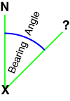
There are many different scenarios that lead to plotting a bearing on a map. Most of them involve a known location, an unknown location, and a north reference. The bearing is the angle formed by two lines that start from the point the measurement is made. One line extends from this point towards North. The other line extends from this point to some distant target. The point at which the measurement is made may be either the known or unknown location.
A single known point and a bearing, is not enough information to determine the location of the unknown point. It will define a line along which the unknown point is located. To locate the unknown point we need at least on more piece of information. That could be another bearing from a different known point. Or it could be a distance from the original known point. Or it could be a map feature that we know the unknown point is located along, like a road, trail, or stream, or a contour line of a given elevation.
Bearings, Azimuths, Headings, and Course
The disciplines of navigation, surveying, and astronomy all have slightly definitions of these terms. Here are some simple definitions that will serve you well for land navigation.
- Bearing - A horizontal arc or angle measured from a north reference line, in a clockwise direction, to a point of interest some distance away from the point of measurement. In land navigation the terms bearing and azimuth are interchangeable.
- Azimuth - See bearing. In land navigation the terms bearing and azimuth are interchangeable.
- Heading - Your forward facing direction of travel. In air and sea navigation heading refers to the forward facing direction of your aircraft or vessel.
- Course - Your desired direction of travel. Your course will be different from your heading when you are "off-course." In air and sea navigation, your course or "course over ground" is the direction of travel of your aircraft or vessel. Here your course may differ from your heading due to influences of wind and current. This is rarely a problem when navigating by foot.
Some reasons to plot bearings onto your map
Location by Resectioning or "Where am I?"
If you can see at least two and preferably three locations that you can identify on your map, you can take compass bearings to these locations, and plot them on your map. Your location will be where the bearing lines cross.
It is often difficult to identify more than one known location that you can see. In this case you can often combine other information about your location to use with a single bearing line. If you are on a trail that you can identify on the map, but you are not sure of your exact location along the trail, You can take a bearing to a known peak, plot that bearing, and know that you are where the bearing line crosses the trail. Note, it is possible the bearing intersects the trail in more than one place. In this case, you will need additional information to determine which crossing is your present location.
You can use any of the following linear features to intersect with one or more bearings. Provided you can identify the feature on the map and you are sure your position in somewhere along the feature you have identified.
- Roads and trails
- Rivers, streams and shorelines
- Ridge lines and spurs
- Fence or power lines
- A contour line at your current elevation
A special case of location by resectioning is useful when you are using a GPSr with a map that does not have a coordinate grid. Rather than using your compass to sight a bearing to a known location, you enter the coordinates of a known location into your GPSr. Using the GOTO Waypoint feature, your GPS will calculate both the bearing and distance from your current location, to the known location on the map. Look for a new tutorial on this method in the coming weeks.
Location by Intersection or "Where is the ______ that I can see in the distance?"
You see something off in the distance, say a plume of smoke. You know where you are and you take a compass bearing from your location to the smoke. Now you can plot a line on your map and know that the source of the smoke is somewhere along that line. Moving to a new, known location and taking a bearing, will result in another line. The source of the smoke should be at the intersection of the two bearing lines. Moving to yet another known location, taking a bearing and plotting it, will provide you some protection from any error you may have made. If the three bearings all cross in close proximity, you can be confident of your results. With only two bearings, errors will not be apparent.
Plotting straight line course segments for route finding
One technique for route finding is to combine a series of straight line "course legs" to reach the desired destination. The techniques discussed in this tutorial can be used to plot these legs onto a map.
The example problem used in this tutorial
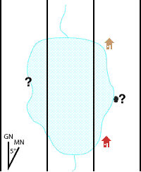
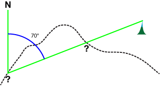
We are staying at a cabin on a small lake somewhere in the north woods. We decide to take a hike around the shore of the lake. At some point on our hike we stop and look across the lake. We can see our cabin. We can also see what looks like a cave entrance along the lake shore. We would like to know where this cave is on our map.
Our cabin is a known location that we can identify on the map. We also know that all three of these locations are along the shoreline of the lake. We do not know our current location, nor do we know the location of the cave.
There will be two parts to solving this problem. First we will take a bearing to our cabin, and plot it on our map. Our location will be where the bearing to our cabin crosses the lake shore. Ideally we could find some other know location and plot a second bearing to give us more confidence in our location.
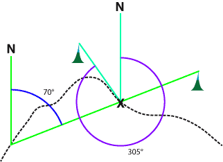
Now we are ready to locate the cave. We take a bearing from our location to the cave entrance, and plot it on the map. The cave is located where the bearing crosses the lake shore across the lake from our location. To improve the confidence in out result, we should move to a new position along the shore line and repeat the entire procedure to give us a second bearing line to the cave.
We will return to this example as we continue through this tutorial.
Understand your north references
So far we have not been very specific about what North means. But there are three different Norths commonly used in navigation, and it is very likely that the North our compass uses and the North we see on our map are different.
If you don't already understand north references and converting between them, you should take a detour to our North Reference Tutorial.
For our example at the lake in the north woods, we will assume that our compass bearings are taken relative to Magnetic North and our map plotting is done using Grid North. In this part of the north woods, Magnetic North is 5° east of Grid North.
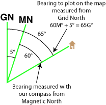
We will likely need to make any adjustments to our north references as we move bearing between our compass and our map. Let's take a look at a declination diagram that shows both Grid and Magnetic North along with the bearing line to the cabin.
The angle between the line to Magnetic North and the line to your cabin, is what we measured with our compass. The angle between the line to Grid North and the line to your cabin, is what we will be plotting on our map. Note the angle from your cabin to Grid North is 5° bigger than the angle from the cabin to Magnetic North. Thus, to convert from a Magnetic North bearing to a Grid North bearing we need to add on 5°. Learning to draw diagram like this one will allow you to figure out all of your north reference conversions, wherever you are in the world. Make sure you use current declination information for your location.
Understanding forward and back bearings
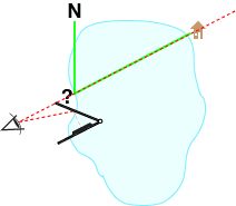
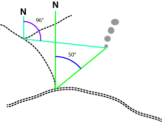
The first compass bearing we need to take at the lake is from our unknown location to our cabin on the far shore. The bearing we end up with represents the angle between a line from Magnetic North to our location, and a line from our location to the cabin. This bearing is a "forward bearing."
But when we go to plot this bearing on our map, we can't plot the angle from our current location since that is what we are trying to find. Instead we plot a bearing from the cabin, as if someone there took a bearing "looking BACK towards our location." This would be called a "back bearing" and will be 180° different from our "forward bearing."
If you took the bearing from the known location, you will be plotting a forward bearing, starting at the known location.
If you took the bearing from the unknown location, you will be plotting a back bearing, starting at the known location.
For more information on forward and back bearings, see our tutorial on forward and back bearings.
This tutorial will show you how to plot a bearing using different techniques and equipment. I usually start my students off using a protractor. A protractor has no moving parts and is conceptually simpler to use.
Techniques for plotting a bearing...
- Plotting a bearing using a protractor
- Plotting a bearing using a baseplate compass
- Plotting a bearing using a baseplate compass adjusted for declination
- Plotting a bearing using a straight edged lensatic compass
- Plotting a bearing using a round lensatic compass
Continue this tutorial on plotting a bearing with these links:
Plotting a second and third bearing to confirm your positionUsing bearings to locate a distant target