Custom Declination Reference Sheet
A reference sheet that shows the magnetic declination and north reference information for where and how you want to use them.
Click here to design your own declination reference sheet.
Understanding the three different north references and how and when to convert between them is one of the most difficult things to learn as a land navigator.
If you are new to all of this I'd recommend that you first visit our North Reference tutorials and videos.
- The written tutorial is here: North References for Navigating with Map, Compass and GPS
- The videos are here: Using your Compass with a Map
When you create one of these reference sheets, you'll start with the location where you will be using it. We will figure out the current magnetic declination for that location and calculate the Grid Convergence angle from True North. No need to rely on out of date declination values from an old map.
Next you get to tell us about your map and how you want to use it, and decide which north reference you want on your compass.
- Which north reference is "up" on you map, True or Grid?
- Which north reference do the north reference lines on your map represent, Grid, True, or Magnetic?
- Will you set your compass up to read bearing relative to Magnetic, True, or Grid North?
Now it time to create your customized Declination Reference Sheet.
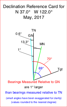
The first panel you will see is a declination diagram for the location you specified with the date the declination was calculated. Depending on your choice, either True North or Grid North will be shown pointing straight up. The angles between the three north references will be indicated. There is also a bearing line to the target. The angles from the two selected north references to the target are shown. Looking at the angles between the target and the various north references is the best way I have found to explain and understand how to convert from on north reference to another.
In the example shown here, the map is True North Up, Grid north is 0.6° west of True North, and Magnetic North is 13.3° east of True North. Bearings to targets measured relative to Grid North are 14° larger that the same bearing measured relative to Magnetic North. Remember bearings are always measured in a clockwise direction starting at the desired north reference.
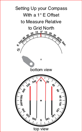
This panel shows how to set up your compass to read bearings in the desired north reference. If you are adjusting your compass to read either True or Grid North bearings you will need to move the orienting arrow in the correct direction and at the correct angle as shown in the diagram.
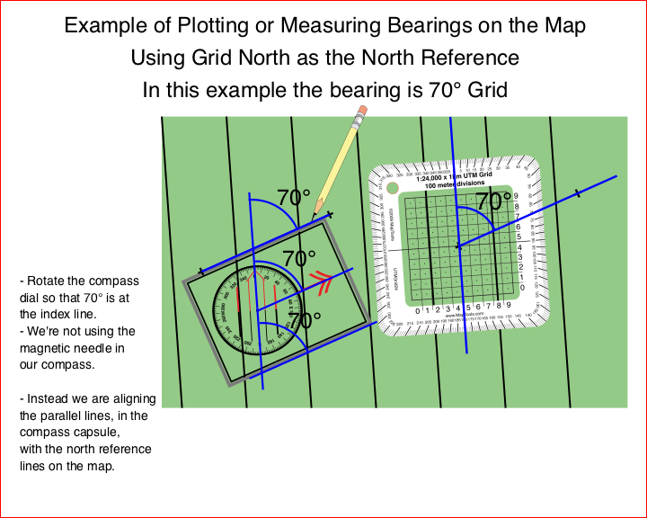
This panel shows an example of plotting or reading a bearing from your map using both your compass and a protractor.
This panel is a quick reference to the math needed to convert from Magnetic North to the north reference you selected for map plotting. If you have set your compass up to read bearings relative to the same north reference you are using to plot on your map, you will not need to do this math. But it's here in case you have to use a compass that can not be adjusted and end up working with magnetic bearings.