1:63,360 Scale Map Ruler


Product Description
This ruler can be used to measure or plot latitude/longitude coordinates, UTM/MGRS/USNG coordinates, and to measure distances in either meters or miles.
On the front side, the ruler has minutes and seconds on one edge and decimal minutes on the other edge, allowing you to use either notation. On the back side, the ruler has distance in meters on one edge, and distance in either miles on the other edge.
Latitude is measured directly with the ruler. But, since a degree of longitude covers a shorter distance as you move towards the poles, the ruler is used on a diagonal to measure longitude. See the usage diagrams for more information.
The ruler is packaged in a handy clear vinyl storage pouch, and includes instructions for use.
| Scale | Maps | Front Side | Back Side | |||
| Span |
Ruler Increments in Minutes |
Ruler Increments in Seconds |
Ruler Increments in meters |
Ruler Increments in Miles or Nautical Miles |
||
| 1:63,360 |
|
5 min | 0.05 min | 1 sec | 50 m | 0.05 mi |
Add to Shopping Cart
Specifications
Scales:- 1:63,360 x 5 minutes
Height: 8.500 in. (216mm)
Width: 1.000 in. (25mm)
Thickness: 0.020 in. (1mm)
Weight: 0.130 oz. (4g)
Package Dimensions:
Height: 8.500 in. (216mm)
Width: 3.000 in. (76mm)
Thickness: 0.030 in. (1mm)
Made in US.
How to use products like this...
Using a map ruler to plot/measure latitude longitude position

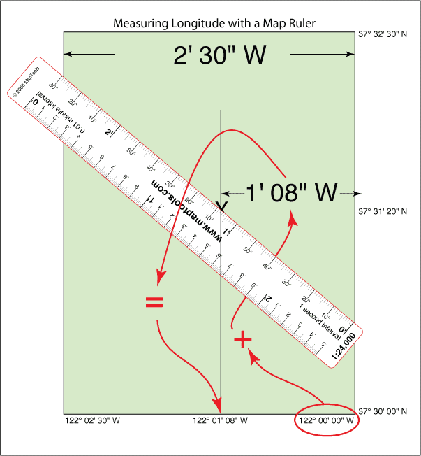
Here is a tutorial on working with latitude longitude coordinates.
Using a map ruler to plot/measure a UTM position with 10m precision
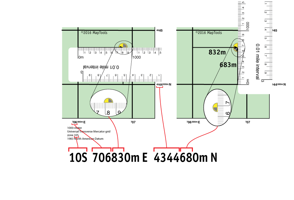
Here is information on using the Universal Transverse Mercator coordinates (UTM).
Here is information on using the United States National Grid (USNG).
Here is information on using the Military Grid Reference System (MGRS).