Ruler Set for DeLorme® Atlas & Gazetteer-Texas 1:400,000


Product Description
This ruler set was designed to be used with the DeLorme® Atlas & Gazetteer for Texas. It contains 13 ruler pairs for measuring latitude longitude coordinates at latitudes ranging from 25° to 37° on a map with a scale of 1:400,000. It also contains rulers for measuring statute miles and kilometers.
The pages of the atlas have a printed lat/lon grid shown with thin black lines. The lines are marked with their (sku,version,type,description) VALUES just outside of the edges of the map, in a degrees, minutes and seconds format and in decimal degrees.
Longitude rulers used north of their design parallel of latitude, will be too long to fit the grid. The ruler should be "close enough" up to about 1° north of the design latitude. As you move north, you may find the next ruler in the set is a closer fit. You can also use the ruler on a slight diagonal between the grid lines to compensate for the extra length.
These rulers are somewhat different than our regular plastic rulers...
- They are printed on a 10 mil polyester stock. Waterproof, weatherproof, and tear proof, but a bit thinner than our stock rulers.
- They are 1.5 inches wide and 8.5 inches long.
We make these rulers using our custom ruler printing process. If you have need of a map ruler that not in one of our sets, check out the custom map ruler design page.
Add to Shopping Cart
Specifications
Scales:- 1:400,000 x 40 minutes
- 1:400,000 x 45 miles
- 1:400,000 x 70 kilometers
Height: 8.500 in. (216mm)
Width: 1.500 in. (38mm)
Thickness: 0.007 in. (0mm)
Weight: 0.050 oz. (1g)
Package Dimensions:
Height: 8.500 in. (216mm)
Width: 3.000 in. (76mm)
Thickness: 0.200 in. (5mm)
Made in US.
How to use products like this...
Measuring the lat/lon coordinates of a point on the map
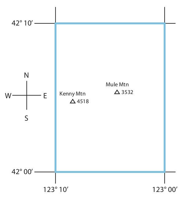
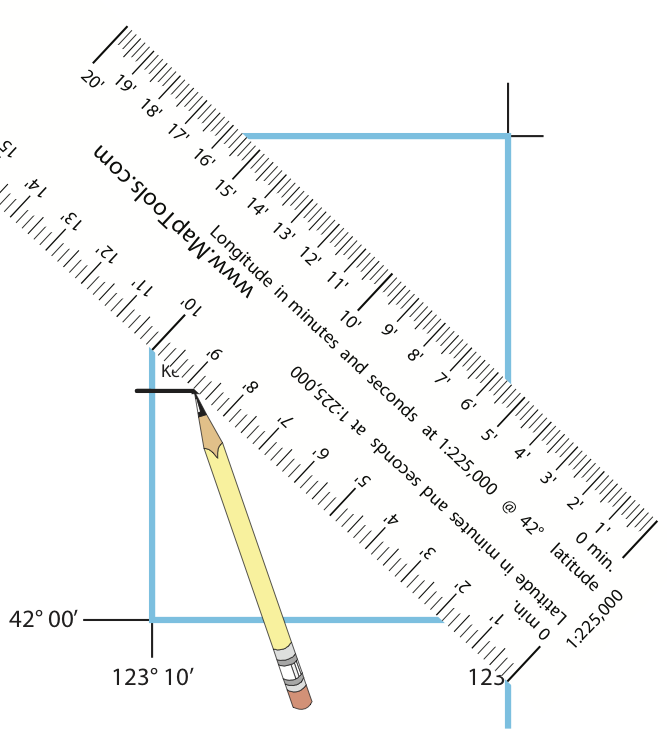
This example uses a 1:225,000 scale map with a 10 minute (10') latitude/longitude grid. It also also using a ruler marked in minutes and seconds. The example point is just north of 42° latitude, so we are using a longitude ruler designed for a 42° latitude. Your map may be a different scale and the grid size may be different. You will want to use a ruler that matches your map scale, is marked in the lot/lon coordinate format you want to use, and is designed for the latitude where you are using it.
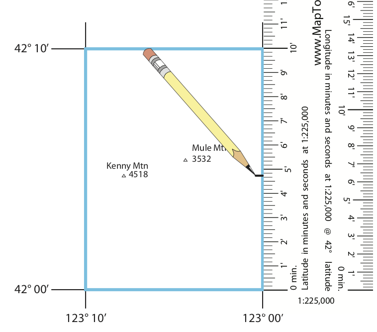
For this example we are going to measure the lat/lon coordinates for Mule Mtn.
Mule Mtn. is north of the N 42° 00’ grid line and west of the W 123° 00’ grid line. We’ll use our ruler to find out how much further north and west it is.
Use any Latitude scale from the ruler set. They are all identical.
Place the latitude scale, running north south, with the zero end on the 42° 00’ grid line, and the edge touching Mule Mtn.
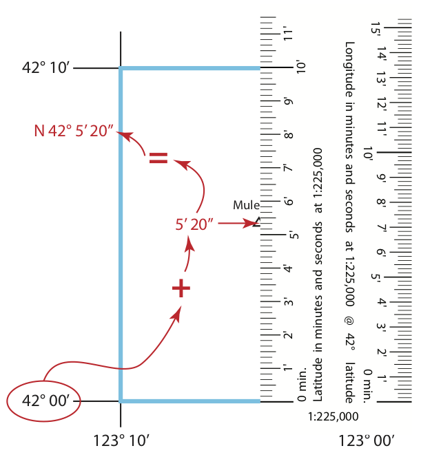
Mule Mtn. is 5’ 20” north of the southern grid line at N 42° 00’. So the latitude of Mule Mtn. is N 42° 05’ 20”.
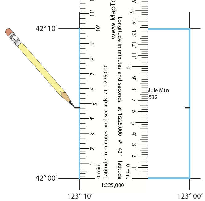
Locate the longitude ruler for 42° from the ruler set.
Place the longitude scale, running east west, with the zero end on the 123° 00’ grid line, and the edge touching Mule Mtn.
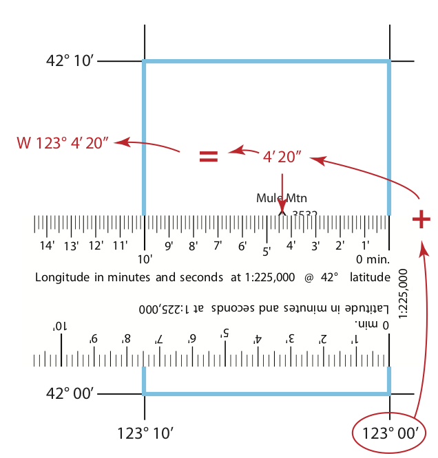
Mule Mtn. is 4’ 20” west of the eastern grid line at W 123° 00’. So the longitude of Mule Mtn. is W 123° 04’ 20”.
Plotting latitude longitude coordinates from your GPS
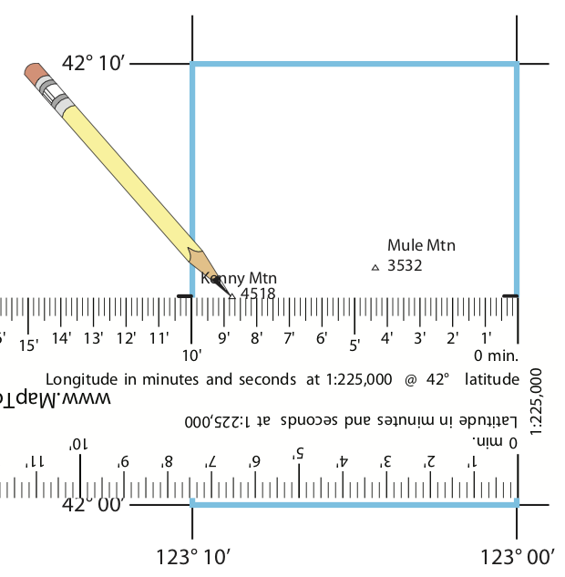
We’ll use the coordinates of N 42° 4’ 43” W 123° 8’ 25” for this example. Make sure your GPS receiver is set up to display coordinates in the HDDD°MM’ SS.SS” coordinate format, and that it is using a map datum that matches your map.
Select a ruler from the set that matches the latitude of the coordinates to be plotted. (For the example that would be 42°.) Also select one of the other rulers to use for measuring the latitude. (All of the latitude rulers in the set are identical.)
Place the ruler you selected to measure longitude with, on the southern edge of the indicated lat/lon grid rectangle. For the example that would be the grid bounded by 42° 00’ on the south, 42° 10’ on the north, 123° 00’ on the east, and 123° 10’ on the west. Place zero end on the eastern longitude grid line. Orient the ruler east-west. The ruler may be longer than the grid, that’s ok. Place the ruler you selected to measure latitude with, on the eastern edge of the indicatedlat/lon grid rectangle. Place zero end on the southern latitude grid line. Orient the ruler north-south. The ruler may be longer than the grid, that’s ok.
Slide the longitude ruler north to the indicated latitude, an additional 4’ 43” seconds north for this example. Keep the ruler parallel to the latitude grid lines.
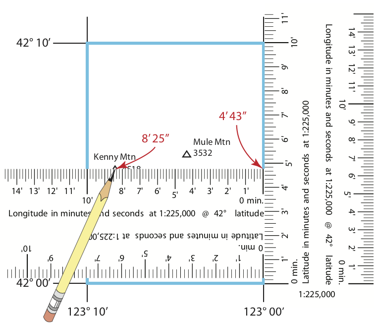
Measure west to the indicated longitude to the west using the longitude ruler, an additional 8’ 25” for the example.
In this example the GPS supplied coordinates, plot on the top of Kenny Mtn.
If you only have one ruler...
Use the latitude scale and a pencil to make small marks on both sides of the grid at the latitude you are plotting.
Now place the longitude scale using the marks you just made.
If you do not have a ruler for your longitude...
Use a longitude scale for a location closer to the equator. You will need to use it at an angle, so that the zero end and the marking for the grid spacing are on the edged of the grid. Using the ruler at an angle like this essentuall "shrinks" it to fit in the grid.
Connecting the two latitude markes with a line will make it easier to figure out where the plotted longitude lies along the line representing the plotted latitude.
Slide the ruler up and down, until the desired longitude mark is on the latitude line you marked.
Here is an example with a longitude ruler designe for 40°.
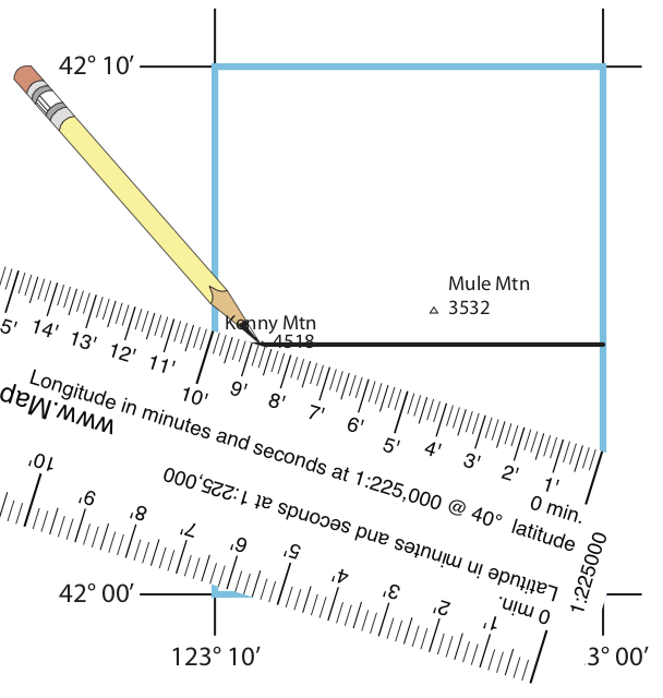
You can even use the latitude scale, since it is the same size as a longitude scale at Equator. The angle for the ruler to fit will be the same as the latitude. You may need to extend the edges of the grid line or place the ruler on the oposite diagonal to reach all points within the grid.
Here is a tutorial on working with latitude longitude coordinates.