Tools for UTM, MGRS, and USNG Coordinates
Grid Style ToolsSlot Style Tools
Corner Ruler or Roamer Style Tools
Military Style Tools
Mini Corner Style Tools
Ruler Style Tools
Looking for a specific map scale... try our product listings by scale
Learn more about UTM, MGRS, and USNG Coordinates
Not sure if UTM Coordinates are the right choice... Learn more about Choosing a Coordinate System
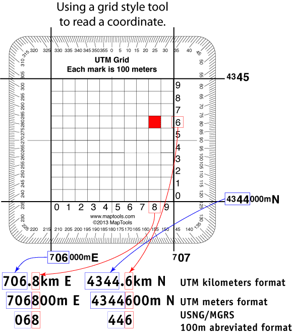
Grid Style Tools
Grid style tools are quick and easy to use and understand. This makes them a great tools for beginners. The tools fit within the grid lines, and visually divides it into a 10 by 10 grid. These smaller grids are numbered 0 to 9 from east to west and from north to south. A point that falls inside a smaller grid gets the easting and northing values of the smaller grid added on the easting and northing of the map grid. Partial grids at the edges of the map are no problem, just place the tool as if the entire grid was present.
The two disadvantages of this style tool are the inability to place a mark on the map without first moving the tool. And the difficulty of determining a location with more precision that a tenth of the map grid spacing.
Grid Style Product List
|
1:24,000 Scale Pocket Size UTM Grid Fast and easy UTM plotting Scales: 1:31,680 x 1km |

|
|
1:25,000 Scale Pocket Size UTM Grid Fast and easy UTM plotting Scales: 1:25,000 x 1km |

|
|
1:50,000 Scale Pocket Size UTM Grid Fast and easy UTM plotting Scales: 1:50,000 x 2km |

|
|
1:100,000 Scale UTM Grid For 1° X 2° USGS & BLM Maps Scales: 1:100,000 x 10km |

|
|
1:31,680 Scale Pocket Size UTM Grid Philmont Scout Ranch, McKenzie Boundary Waters maps and Halfmile's PCT maps |

|
Slot Style Tools
The Slot Style is my personal favorite tool style. All the accuracy you need. Access to mark on the map. Easy to keep parallel to the grid lines. And quick to verify that it fits in the grid. What's not to like.
Conceptually they are harder to understand and I often get the question, "Why is the east-west ruler numbered backwards?" The tool is used by sliding it across the east-west direction of the grid and reading the easting value at the west edge of the grid. In this aspect, it is similar to a corner roamer. The northing is read through the vertical slot, with values increasing as you move to the north.
Slot Style Product List
|
1:24,000 Pocket Sized Slot Tool Fast and easy UTM plotting Scales: 1:24,000 x 1km |

|
|
1:12,000 & 1:24,000 Slot Tool Fast and easy UTM plotting Scales: 1:12,000 x 1km , 1:24,000 x 1km |

|
|
1:24,000 Credit Card Sized UTM Slot Tool also includes distance in miles and feet Scales: 1:24,000 x 1km |

|
|
1:25,000 Credit Card Sized UTM Slot Tool also includes distance in miles and feet Scales: 1:25,000 x 1km |

|
|
Pocket Sized UTM Slot Tool - Degrees Compass rose marked in degrees. Scales: 1:24,000 x 1km , 1:25,000 x 1km |

|
|
Pocket Sized UTM Slot Tool - 90 Degree Quadrants Compass rose marked in 90 degree quadrants. Scales: 1:24,000 x 1km , 1:25,000 x 1km , 1:50,000 x 1km |

|
|
Pocket Sized UTM Slot Tool - Mils Compass rose marked in mils. Scales: 1:24,000 x 1km , 1:25,000 x 1km , 1:50,000 x 1km |

|
|
Military Style UTM/MGRS Coordinate Scale Coordinate Scale and Protractor - GTA 5-2-12 Scales: 1:25,000 x 1km , 1:50,000 x 1km , 1:100,000 x 1km , 1:250,000 x 10km† |

|
|
REDs Coordinate Scale and Protractor
Risk Estimate Distances for Common Mortar Rounds Scales: 1:10,000 x 500m , 1:25,000 x 1km , 1:50,000 x 2km , 1:100,000 x 5km† , 1:250,000 x 10km† , 1:500,000 x 20km† |

|
|
Improved Military Style UTM/MGRS Coordinate Scale Compass Rose in both Degrees and Mils Scales: 1:10,000 x 500m , 1:24,000 x 1km , 1:25,000 x 1km , 1:50,000 x 2km , 1:100,000 x 5km† , 1:250,000 x 10km† , 1:500,000 x 20km† |

|
|
Round Military Coordinate Scale and Protractor Large Print, Compass Rose in Degrees Scales: 1:10,000 x 500 m , 1:24,000 x 1km , 1:25,000 x 1km , 1:50,000 x 2km , 1:100,000 x 5km† , 1:250,000 x 10km† , 1:500,000 x 20km† |

|
|
Round Military Coordinate Scale and Protractor Large Print, Compass Rose in 90 Degree Quadrants Scales: 1:10,000 x 500 m , 1:24,000 x 1km , 1:25,000 x 1km , 1:50,000 x 2km , 1:100,000 x 5km† , 1:250,000 x 10km† , 1:500,000 x 20km† |

|
|
UTM Slot Tool (14 Scales) 14 Scales in a compact tool Scales: 1:10,000 x 1km† , 1:15,000 x 1km , 1:20,000 x 1km , 1:24,000 x 1km , 1:25,000 x 1km , 1:30,000 x 1km , 1:62,500 x 5km , 1:100,000 x 10km , 1:125,000 x 10km , 1:150,000 x 10km† , 1:200,000 x 10km† , 1:250,000 x 10km† , 1:300,000 x 10km† , 1:1,000,000 x 100km† |

|
|
Tom Harrison Map Series UTM Slots Scales: 1:10,000 x 1km† , 1:24,000 x 1km , 1:31,680 x 1km , 1:42,240 x 2km , 1:47,520 x 2km , 1:48,000 x 2km , 1:63,360 x 5km , 1:100,000 x 10km , 1:1,000,000 x 100km† |

|
|
Green Trails UTM Slots Pocket sized Scales: 1:69,500 x 2km |

|
|
British Columbia UTM Slots Scales: 1:20,000 x 1km , 1:50,000 x 2km |

|
|
Natl Geo Kiosk and !TOPO Maps UTM Slots Scales: 1:24,000 x 1km , 1:30,750 x 1km |

|
|
USFS Maps UTM Slots Scales: 1:10,000 x 1km† , 1:24,000 x 1km , 1:25,000 x 1km , 1:62,500 x 5km , 1:63,360 x 5km , 1:100,000 x 10km , 1:126,720 x 10km , 1:250,000 x 10km† |

|
|
UTM Slots for 1:31,680 1 inch = 1/2 mile Philmont Scout Ranch, McKenzie Boundary Waters maps and Halfmile's PCT maps Scales: 1:24,000 x 1km , 1:31,680 x 1km |

|
|
Natl. Geo. Trails Illustrated Maps UTM Slots for 1:40,680 Scales: 1:24,000 x 1km , 1:40,680 x 1km |

|
|
Pocket Sized UTM Slots for My Topo Maps Scales: 1:24,000 x 1km , 1:25,000 x 1km , 1:30,000 x 1km , 1:35,000 x 1km |

|
|
Pocket Sized UTM Slots for My Topo Air Photos Scales: 1:5,000 x 250m , 1:10,000 x 500m , 1:15,000 x 500m |

|
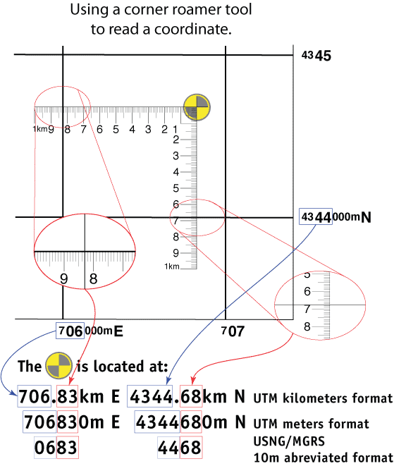
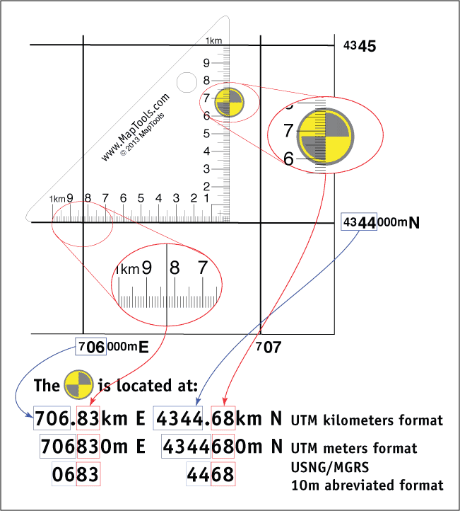
Corner Ruler or Roamer Style Style Tools
A traditional roamer tool that is used by sliding the tool within the grid and reading the easting and northing values at the western and southern grid lines.
Here is a short piece on why I prefer to use a Slot Style tool
Corner Ruler or Roamer Style Product List
|
Adventure Racing Corner Rulers One Tool, 5 Common Scales Scales: 1:10,000 x 1km , 1:15,000 x 1km , 1:24,000 x 1km , 1:25,000 x 1km , 1:30,000 x 1km , 1:100,000 x 10km† , 1:150,000 x 1km† , 1:250,000 x 10km† , 1:300,000 x 10km† , 1:1,000,000 x 10km† |

|
|
Pocket Sized UTM Corner Rulers Scales: 1:24,000 x 1km , 1:25,000 x 1km , 1:50,000 x 1km |

|
|
UTM Corner Rulers Overlay - 7 Scales Scales: 1:24,000 x 1km , 1:25,000 x 1km , 1:50,000 x 5km , 1:62,500 x 5km , 1:63,360 x 5km , 1:100,000 x 10km , 1:150,000 x 10km , 1:250,000 x 10km |

|
|
Aerial Photo UTM Corner Rulers Lots of Scales, More Precision Scales: 1:5,000 x 500m , 1:8,000 x 500m , 1:12,000 x 500m , 1:15,000 x 500m |

|
Military Style Tools
I get a lot of comments from both active duty and retired military folks about how superior our Coordinate Scale and Protractor is to the standard issue version. Here is why it's better...
- Our cutouts are in the right location.
- Our text is crisp and easy to read.
- Our corners are rounded, so the tool doesn't poke holes in you or your pockets.
- Our tools are printed on 0.030 in. thick stock to make them tough, with just a bit of flexibility.
- Our tools have a clear ultraviolet cured protective layer to keep the markings from wearing off.
- Our tool are made in the United States.
Our Improved Coordinate Scale and Protractor is a popular alternative to the basic tool. Here is what we've done to make it better.
- We have added bands of white ink under the protractor markings. This has two benefits. First off, the tool doesn't just "disappear" when you set it down. Second, it's easier to read the angle from the protractor.
- We have moved from a triangular cutout to a narrow slot. This gives us enough extra "real estate" to extend the 1:100,000 scale to span 5km. And to add a 1:24,000 scale making the tool usable on the most common map scale in the Continental United States
- Finally we have drilled a hole in the center of the protractor, so you don't have to. This allows a bit of thread or elastic to be used to extend the bearing line away from the edge of the protractor.
We are able to supply our Military Style Tools in quantities ranging from 1 to tens of thousands. We accept US Government purchase cards for individuals or units wishing to make small purchases directly. We will also be happy to work with your procurement folks.
Military Style Product List
|
Round Military Coordinate Scale and Protractor Large Print, Compass Rose in Degrees Scales: 1:10,000 x 500 m , 1:24,000 x 1km , 1:25,000 x 1km , 1:50,000 x 2km , 1:100,000 x 5km† , 1:250,000 x 10km† , 1:500,000 x 20km† |
|
|
Improved Military Style UTM/MGRS Coordinate Scale Compass Rose in both Degrees and Mils Scales: 1:10,000 x 500m , 1:24,000 x 1km , 1:25,000 x 1km , 1:50,000 x 2km , 1:100,000 x 5km† , 1:250,000 x 10km† , 1:500,000 x 20km† |
|
|
REDs Coordinate Scale and Protractor
Risk Estimate Distances for Common Mortar Rounds Scales: 1:10,000 x 500m , 1:25,000 x 1km , 1:50,000 x 2km , 1:100,000 x 5km† , 1:250,000 x 10km† , 1:500,000 x 20km† |
|
|
Military Style UTM/MGRS Coordinate Scale Coordinate Scale and Protractor - GTA 5-2-12 Scales: 1:25,000 x 1km , 1:50,000 x 1km , 1:100,000 x 1km , 1:250,000 x 10km† |
|
Mini Corner Style Tools
If you are seeking the smallest and lightest tools, the mini corners are for you. It's just a tiny triangle that you slide across the grid. There is a lanyard hole, so that it dosen't get lost. On our most recent re-print we added a patch of white ink to our 24k, 25k and 50k tools to keep them from disappearing when you set them down.
Mini Corner Style Product List
|
Mini Corner Ruler for 1:12,000 Scales: 1:12,000 x 1km |

|
|
Mini Corner Ruler for 1:24,000 Scales: 1:24,000 x 1km |

|
|
Mini Corner Ruler for 1:25,000 Scales: 1:25,000 x 1km |

|
|
Mini Corner Ruler for 1:30,000 Scales: 1:30,000 x 1km |

|
|
Mini Corner Ruler for 1:35,000 Scales: 1:35,000 x 1km |

|
|
Mini Corner Ruler for 1:47,520 Scales: 1:47,520 x 2km |

|
|
Mini Corner Ruler for 1:48,000 Scales: 1:48,000 x 2km |

|
|
Mini Corner Ruler for 1:50,000 Scales: 1:50,000 x 1km |

|
|
Mini Corner Ruler for 1:62,500 Scales: 1:62,500 x 2.5km |

|
|
Mini Corner Ruler for 1:63,360 Scales: 1:63,360 x 2.5km |

|
Ruler Style Tools
Our Map Rulers are primarily designed for plotting latitude/longitude coordinates. But the all have an edge marked in meters or kilometers that can be used to measure UTM, MGRS, and USNG coordinates as well. Better yet we have them for lots of different map scales.
Ruler Style Product List
|
Adventure Set of 4 Map Rulers 1:24,000 1:62,500 1:100,000 1:126,720 |

|
|
Map Rulers - USGS Set of 10 Map Rulers Scales for most maps published by USGS |

|
|
Map Rulers - Explorer Set of MapRulers |

|
|
Map Rulers - Nautical Set |

|
|
1:5,000 Scale Nautical Map Ruler Scales: 1:5,000 x .5 minutes |

|
|
1:10,000 Scale Nautical Map Ruler Scales: 1:10,000 x .5 minutes |

|
|
1:15,000 Scale Nautical Map Ruler Scales: 1:15,000 x 1 minute |

|
|
1:20,000 Scale Nautical Map Ruler Scales: 1:20,000 x 1 minute |

|
|
1:24,000 Scale Map Ruler Scales: 1:24,000 x 2.5 minutes |

|
|
1:25,000 Scale Map Ruler Scales: 1:25,000 x 2.5 minutes |

|
|
1:30,000 Scale Nautical Map Ruler Scales: 1:30,000 x 2 minutes |

|
|
1:30,750 Scale Map Ruler Scales: 1:30,750 x 2.5 minutes |

|
|
1:40,000 Scale Nautical Map Ruler Scales: 1:40,000 x 2 minutes |

|
|
1:40,680 Scale Map Ruler Scales: 1:40,680 x 4 minutes |

|
|
1:50,000 Scale Map Ruler Scales: 1:50,000 x 5 minutes |

|
|
1:50,000 Scale Stainless Steel Ruler 0-30 kilometers, 0-18 miles, and 15 minutes of Latitude Scales: 1:50,000 x 30km , 1:50,000 x 18 miles , 1:50,000 x 15 minutes |

|
|
1:62,500 Scale Map Ruler Scales: 1:62,500 x 5 minutes |

|
|
1:63,360 Scale Map Ruler Scales: 1:63,360 x 5 minutes |

|
|
1:69,500 Scale Map Ruler Scales: 1:69,500 x 5 minutes |

|
|
1:75,000 Scale Map Ruler Scales: 1:75,000 x 5 minutes |

|
|
1:77,000 Scale Nautical Map Ruler Scales: 1:77,000 x 5 minutes |

|
|
1:80,000 Scale Nautical Map Ruler Scales: 1:80,000 x 5 minutes |

|
|
1:80,000 Scale x 7.5 min Nautical Map Ruler Scales: 1:80,000 x 7.5 minutes |

|
|
1:100,000 Scale Map Ruler Scales: 1:100,000 x 10 minutes |

|
|
1:100,000 Scale Nautical Map Ruler Scales: 1:100,000 x 10 minutes |

|
|
1:125,000 Scale Map Ruler Scales: 1:125,000 x 7.5 minutes |

|
|
1:126,720 Scale Map Ruler Scales: 1:126,720 x 7.5 minutes |

|
|
1:150,000 Scale Map Ruler Scales: 1:150,000 x 15 minutes |

|
|
1:160,000 Scale Map Ruler Scales: 1:160,000 x 15 minutes |

|
|
1:200,000 Scale Map Ruler Scales: 1:200,000 x 15 minutes |

|
|
1:250,000 Scale Map Ruler Scales: 1:250,000 x 15 minutes |

|
|
1:280,000 Scale Map Ruler Scales: 1:280,000 x 20 minutes |

|
|
1:300,000 Scale Map Ruler Scales: 1:300,000 x 30 minutes |

|
|
1:320,000 Scale Map Ruler Scales: 1:320,000 x 30 minutes |

|
|
1:400,000 Scale Map Ruler Scales: 1:400,000 x 30 minutes |

|
|
1:500,000 Scale Map Ruler Scales: 1:500,000 x 30 minutes |

|