A Quick Guide to Using UTM Coordinates
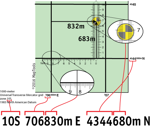
Standing at the center of the marker shown on the map below, a GPS unit set to display position in UTM/UPS format, would report a location of:

Let's look at where the various parts of the UTM position come from on the map.

The map has grid lines spaced every kilometer or 1000 meters. The grid is labeled with UTM coordinate values. The vertical grid lines determine East-West position and the horizontal grid lines determine North-South position.
Look along the bottom edge of the map at the labels for the vertical grid lines.
The label,
![]() , reads "seven hundred and six thousand meters East." The label,
, reads "seven hundred and six thousand meters East." The label,
![]() , is an abbreviation for,
, is an abbreviation for,
![]() The two grid lines are 1000 meters apart. The horizontal grid lines are
labeled in a similar manner.
The two grid lines are 1000 meters apart. The horizontal grid lines are
labeled in a similar manner.
The 10S is the Grid Zone Designation you are in. The Grid Zone is necessary to make the coordinates unique over the entire globe.
The top set of numbers, 706832, represent a measurement of East-West position, within the Grid Zone, in meters. It's called an Easting. Using a map with a 1000m grid, the first digits are come from the label for the grid line to the west of the position. The last 3 digits are the distance in meters measured from the western grid line.
The bottom set of numbers, 4344683, represent a measurement of North-South position, within the Grid Zone, in meters. It's called a Northing. Using a map with a 1000m grid, the first digits are come from the label for the grid line to the south of the position. The last 3 digits are the distance in meters measured from the southern grid line.
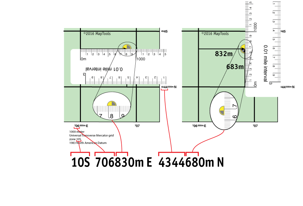
Using various tools to plot and measure UTM positions on a map
Click on the tab for the tool style you want to know more about.
Using a grid style tool to plot/measure a UTM position with 100m precision

Using a slot style tool to plot/measure a UTM position with 10m precision
Using a corner ruler roamer style tool to plot/measure a UTM position with 10m precision

Using a mini corner style tool to plot/measure a UTM position with 10m precision

Using a map ruler to plot/measure a UTM position with 10m precision
The precision of the Easting and Northing measurements
A UTM coordinate's Easting and Northing are both distance measurements made in meters. But this leaves us with a dilemma when we have not measured with one meter precision. What to do with the unknown digits. Let's look at the Easting of a point that is 146m east of the western grid line. T hat would, in our example above, give it an Easting of 706146m E. But on a large scale map, no tool will be able to measure to the nearest meter. At best you'll get 10 meters, and if you're eyeballing it you'll be good to get 100m accuracy. But we still have to write all the digits down to the meter. The convention is to fill in the unknown/unmeasured digits with zeros, and to avoid any rounding up. So our easting becomes 706140m E or 706100m E. The trouble is we don't know if the location we are measuring was located with great accuracy at 706100m E, or if we just did a 100m rough measurement and the location could have an easting between 706100m E and 706199m E. One possible solution is to write the Easting an Northing in kilometers, using as many digits after the decimal point as we have measurement accuracy. For more on this idea check out our page on kUTM Coordinates.
For improved clarity, write the measurement units with the Easting and Northing
In the world of map coordinates, there are a lot of different coordinate formats. If you just run a bunch of digits together with no spacing or units, you run the risk of having someone else misunderstand what coordinate format you are using. In the case of UTM, I suggest writing "m E" for "meters East" after the Easting, and "m N" for "meters North" after the Northing. When communicating a coordinate by voice, say the words "meters East" after the Easting and "meters North" after the Northing.
There are several documented cases where a string of digits was passed, usually by voice, to someone else who misinterpreted the coordinate format. In one case this led to the rescue helicopter being sent 30 miles away from the actual incident.
Learn more about...
Map Datums and why they are so important
Locating MGRS grid information on USGS topographic maps
Some of the history behind the military adoption of UTM and MGRS